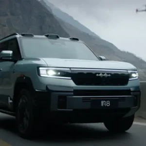
Direct supply line for high-demand electric vehicles, specialized hybrid transport solutions, and custom dual-purpose machinery.
The global industrial landscape is undergoing a major technological transformation, powered by the rise of the low-altitude economy. Industrial Unmanned Aerial Systems (UAS) are no longer just basic data collectors. Today, they serve as the foundational hardware for advanced GIS mapping, precision digital twins, and strategic airspace management. As a premier provider of integrated supply chain solutions and tactical UAS technologies, Tianli International Trade Group leads the way in bridging the gap between high-precision aerial data collection and secure operations.
Our comprehensive industrial solutions integrate drone mapping technologies with robust security frameworks. This means organizations can deploy unmanned flight technologies while keeping control over their physical and digital environments. From surveying remote mining terrains to protecting critical national infrastructure with high-performance UAS detection platforms, we provide end-to-end support that keeps our clients ahead of emerging threats and operational challenges.
Deploying multi-spectral sensors to analyze crop health, calculate vegetation indices (NDVI), optimize fertilizer use, and monitor forest ecosystems efficiently.
Generating highly accurate 3D photogrammetric models of bridges, highways, power lines, and rail systems to streamline long-term maintenance cycles.
Securing low-altitude airspace with integrated detection, tracking, and countermeasures to protect operations from unauthorized or hostile drones.
Industrial drone mapping and hardware deployment are growing rapidly worldwide. As projects scale, organizations require supply chain partners who can deliver complex machinery alongside complete regulatory compliance and export credentials. Tianli Group operates at this critical intersection, leveraging decades of collective manufacturing experience and industrial know-how to deliver solutions globally.
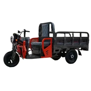
The transition to electric drivetrains and sustainable power sources has transformed the logistics industry. We address this shift by integrating our New Energy Vehicle Solutions and zero-emission micro-utility fleets—such as high-quality electric tricycles—with our advanced UAS operations. This ensures that field crews, whether they are performing remote surveys or securing industrial perimeters, have access to reliable, eco-friendly transit and support systems.
With an established global network, Tianli simplifies the procurement process for international buyers. We handle everything from parallel auto exports to specialized UAS hardware shipments. By combining multi-brand sourcing with complete certification and quality inspections, we ensure all equipment arrives ready to deploy and meets local requirements.

Operating industrial drones across borders requires navigating a complex web of civil aviation laws, radio frequency regulations, and local safety rules. For example, drone mapping projects in the United States must comply with the Federal Aviation Administration's (FAA) Part 107 regulations. Meanwhile, operations in European Union member states must align with European Union Aviation Safety Agency (EASA) guidelines. These rules include strict standards for Remote ID, flight over people, and operation beyond visual line of sight (BVLOS).
In addition to aviation rules, data security and privacy laws like Europe's GDPR are critical when capturing high-resolution imagery of public areas. Our systems support offline data processing, encrypted telemetry streams, and private storage networks. This guarantees that sensitive geographical data remains secure, protected, and fully under the control of the operating organization.
To keep your operations running smoothly, we offer robust after-sales support and local training programs. Our service network provides parts replacement, maintenance diagnostics, and firmware updates for all exported hardware. This minimizes downtime and protects your long-term technology investments.

To understand the true value of industrial UAS platforms, we can look at their real-world applications in challenging environments. For example, in open-pit mining operations, drone photogrammetry is used to calculate stockpile volumes and monitor slope stability. This data can be collected in a fraction of the time required by ground crews, without exposing workers to dangerous terrain.
In urban development, engineers use drone-generated orthomosaics to build highly detailed 3D models of existing layouts. This allows them to plan new construction with centimeter-level accuracy, ensuring projects fit perfectly within current infrastructure.
When combined with our low-altitude security platforms, these systems provide comprehensive protection for critical assets like power plants, oil refineries, and water reserves. While mapping drones monitor the health of these facilities, our integrated counter-UAS platforms stand guard to detect and neutralize any unauthorized aerial threats, ensuring safe and uninterrupted operations.
Using RTK (Real-Time Kinematic) and PPK (Post-Processed Kinematic) corrections to achieve sub-centimeter accuracy for cadastral maps and construction layouts.
Mapping floodplains, assessing post-storm damage, tracking coastal erosion, and gathering real-time data to help emergency services deploy resources safely.
Combining thermal imaging patrols with active RF jamming systems to secure sensitive facility borders and restrict unauthorized flights.
The drone mapping industry is moving fast, driven by breakthrough developments in artificial intelligence, sensor design, and battery efficiency. At Tianli, we continuously update our technology roadmap to integrate these innovations. This ensures that the platforms and services we deliver to our global clients remain at the cutting edge of industrial performance.
Explore our complete selection of hybrid vehicles, high-capacity utility electric tricycles, and dual-purpose industrial platforms.