Engineered for long-endurance missions, precise mapping, and integrated remote aerial deployment.
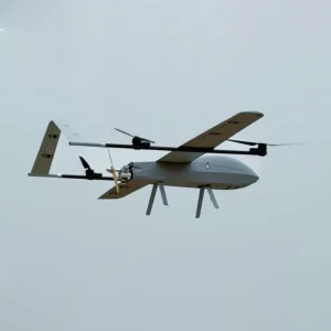


Australia boasts one of the most advanced and rapidly evolving low-altitude economies in the world. Driven by vast spatial geography, resource-rich mining basins, and critical agricultural zones, the reliance on high-performance unmanned aerial vehicles (UAVs) has moved from simple monitoring to absolute operational necessity. The regional terrain requires robust VTOL (Vertical Take-Off and Landing) options capable of navigating extreme temperatures, high winds, and remote, disconnected territories.
Historically, key industries such as mineral extraction in Western Australia (Pilbara region) and massive agricultural cultivation across New South Wales and Queensland have fueled the demand for heavy-payload, long-endurance platforms. Furthermore, the Civil Aviation Safety Authority (CASA) framework has established highly detailed compliance rules under CASA Part 101, paving the way for legally compliant, BVLOS (Beyond Visual Line of Sight) flights that unlock massive productivity gains in automated infrastructure scanning, geological mapping, and emergency services.
As a global exporter and supply chain expert, Tianli provides specialized vehicle and UAV integrations designed to match these local regulatory barriers, ensuring all telemetry bands, radio transmission frequencies, and flight control protocols sync perfectly with Australian communication standards.
The next phase of unmanned aviation is defined by a shift toward software-defined flight, clean power, and real-time edge processing. We have established a comprehensive technology roadmap focusing on four critical pillars:
Transitioning from traditional lithium polymer configurations to solid-state battery chemistry and hydrogen-electric fuel cells. This evolutionary shift expands UAV flight endurance past 3 to 5 hours, meeting the needs of expansive Australian agricultural properties and massive outback infrastructure lines.
Integration of low-latency, onboard AI computing blocks designed to run real-time classification algorithms, instant thermal mapping, and automated structural defect flagging without requiring remote cloud rendering during operation.
Modular quick-release gimbal systems equipped with LiDAR sensors, radiometric thermal lenses, and high-definition optical payload units to ensure seamless crossover applications between mapping and physical asset management.
Operating at the intersection of scale, quality certification, and proven field deployments.
Modern UAV operations require cohesive ecosystem solutions rather than isolated, generic hardware packages. Tianli specializes in engineering complete application ecosystems to address regional requirements:
Equipped with high-capacity chemical payloads and multispectral imaging systems, our agricultural UAV platforms allow local farmers to identify crop health anomalies, map soil moisture content, and apply targeted inputs with centimeter-level precision.
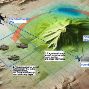
For open-cut mines and complex quarries, our VTOL platforms map vertical walls and stockpile volumes in record time. These systems output high-density point clouds that integrate directly with spatial modeling suites like Maptek and Vulcan.
With the proliferation of commercial drones, protecting high-risk airspaces is vital. We supply fully integrated radio-frequency (RF) passive detection grids, smart directional jammer guns, and automated perimeter protection loops.
Operating from Shandong, our manufacturing centers leverage China's world-leading micro-component, hardware, and structural material supply chains. By applying Factory 4.0 principles, we ensure every UAV system and support unit conforms to strict global safety tolerances:
For Australian enterprise clients, this translates into reduced lead times, competitive pricing structures, and robust post-sale component replacement support.
Ensuring clear compliance with local regulations is central to our exporting philosophy. Operating drones in Australian commercial airspace requires structured coordination between technology manufacturers, operators, and safety organizations.
All UAV platforms exported by Tianli to Australian firms can be pre-configured with local geofencing data, preventing inadvertent incursions into commercial airport flight zones or sensitive military airspace. Furthermore, our radio equipment matches Australian Communications and Media Authority (ACMA) RF guidelines, utilizing clean 2.4GHz, 5.8GHz, or custom telemetry frequencies to avoid interference with emergency service radio channels.
Whether you are setting up a Remote Operator Certificate (ReOC) framework, obtaining a remote pilot license (RePL) training platform, or applying for specialized BVLOS approval, our engineering team supplies complete documentation packs, manufacturing QA reports, and compliance manuals to smooth out your application process.
Browse our extended equipment range, from multi-role VTOL systems to specialized field response vehicles and transporters.


Answering the primary technical, operational, and financial questions from our global commercial buyers.
Contact our supply chain experts today for detailed spec sheets, custom payloads, and competitive bulk pricing.
📩 Request Quotation & Technical Consultation